Friday, December 31, 2010

Freeman Peak - December 30th 2010

Freeman Peak skiing was exceptional today!


We observed numerous D1-D1.5 (small) size crown fractures from the instability cycle that resulted after yesterday storm. Most of the fractures were in terrain features with slope angles in the neighborhood of 36 degrees. Stability evaluation in the area we skied suggested: 'Easy' triggering (CTE), with moderate slip likehood results (Q2), and no evidence of propagation. However, be aware that fracture propagation tests are questionable under soft slab conditions. 

In addition, after a brutal team effort in trail breaking, none of us observed any fracture/crack, propagation, or wumpfs -NO evidence at all of instabilities. Hand pits at various elevations confirmed same results as the snow pit results - the new snow is bonding very well at Freeman on the elevation range (5900-7200 feet) we skied today. But CTEQ2 (X2) results remind us of being vigilant through-out the day, and avoid snow that has become cohesive or "slabby".

Today's moderate winds did not affected the skiing or snow below the 7200 feet with NE and E aspects. The snow at ridge tops developed windslabs, but the wind was loading the SE & S aspects. The only time we observed any evidence of propagation potential was 20 meters or so below an Easterly aspect ridge line with cross-loading. We avoided those pillows.

By the way - it is hard to believe but the recent rain/melt crust is buried 90-100 cm down! Last time I skied Mores Creek Summit Area (Lamar Headwaters) there were 30 cm of pow above the crust, thus at mid elevations the latest storm left behind up to 60 cm of NEW snow.

Chago

PS: Erik, Rick, Andy - it was a pleasure to meet you today! THANKS for helping with the trail breaking.

Tuesday, December 28, 2010

Pilot Peak December 27, 2010 - Lamar Creek Slopes

Today I was surprised by the quality of skiing at the headwaters of the Lamar Creek to the East of Pilot Peak. There is not much I can add after you watch this video.

.

I realize the soundtrack is not a great match, but it was in my mind all day as skinned up and skied down.

I could not rally my sons and friends to accompany me, but I really wanted to tour today the Lamar Creek area. Similar to last Sunday, I had a late start, and it did not helped when the pull-out below the Summit Creek switchback (next to Winter Corner) was not plowed, and I had to get the shovel out and excavate a spot for my vehicle.


The red lines in the Lamar Creek area topo map correspond to the slopes I skied today. The run shown in the video clip are the second through fourth in the clockwise direction.

The green lines are other nice runs I usually ski when I have more time. The terrain at Lamar does not exceeds the 32 degrees of steepness, and with few exceptions besides the nasty terrain traps at the very bottom of the ski runs in red, the terrain can be easily managed when concerned about avalanche stability.

The purple lines denote the "Top of the World" and "Almost Top of the World". Today there were three BC-skiers leaving behind nice looking tracks in that area!

Besides great ski conditions, the snowpack was unremarkable above the 6500 feet at North through East aspects. Below 6500 feet at E to S aspects there was a supportable crust with 30 cm of fun pow, and if you allowed the ski to run free, it was possible to avoid the scratching!

Chago

Monday, December 27, 2010

Sunset West Glades - 12/26/2010

After spending Saturday indoors with the family, cooking delicious dishes, playing table games (and loosing every single darn game!), sharing presents, and enjoying each other company, it was time to play outside!

This morning we had a late start. Sunday was an unsettle weather day, after a quick moving storm front left behind 10-20 cm of new snow. The new snow was soft, but heavily "rimmed". In protected aspects the new snow felt in top of 10-15 cm of unconsolidated snow. The slopes with W/NW/N aspect we skied had between 20 to 35 cm of "FIST" hard now that provided great skiing.


The P in the above topo map denotes the pull-out at Freeman peak, and in red the slopes we skied today. The green lines are two other fun lines we did not have time to ski today, but trust me, they are delightful. In blue are the slopes I skied several weeks ago during my first 2010 Winter Tour. The yellow lines corresponds for to ski lines in "Winter Corner". These ski lines are short, but provide great skiing, particularly during short days when time is limited to tour above the 7000 feet level.

The Sunset Peak West Glades are relatively low in elevation (5600 to 6400 feet), and for few years the snowpack has been too shallow to permit good skiing without doing hand to hand combat with the insidious low elevation "Mores Creek Summit" brush stands. Considering that the Mores Creek Summit area snow depth is 120% of average, we gave it a try to the Sunset West glades above I-21, and we found exciting tight lines with knee deep pow.


The video for today's skiing was edited and put together by my son Fritz. Santa Lourdes was very generous this Christmas, and I got a very cool GoPro HD video camera.

The warm temperatures during the last week have resulted in an "nonreactive" snowpack below 6500 feet even when it is stratified, and various facet layers can be easily detected. Stability evaluation at West and North aspects did not reveal evidence of propagation potential (ECTN) and trigger likelihood (ECT & CT scores above 20 taps) results were "hard". The rain crust buried  (20-35 cm) produced "LOW slip likelihood" results with scores consistent scores in the Q3 range. In addition, hand pit tests and several ski cuts on steep roll-overs did not provided evidence of instability. This was surprising, since I was expecting to see pockets of "surface hoar" and/or "near surface facets" buried by the recent NEW snow. Perhaps the conditions at 6500 feet or below did not favored the formation of SH and/or NSF.

It is worth noting that below the 5 cm thick "pencil hard" crust layer there is a facet layer (4F hardness) undermining a decomposing rain crust layer. The faceting of the "rain crust" is being driven by a temperature gradient above 1 degree Celsius per 10 cm below the crust and facet interface, where warmer snow (-1 Deg C) is providing the energy enabling faceting metamorphism. It is a good idea to keep track of this decomposing rain crust layer, particularly at higher elevations (above the elevations we toured today - 6500 feet) where the crust and facet layer might be thiner and/or more reactive.

Chago

Wednesday, December 22, 2010

Big Creek Summit - Sunday 12/19

Hi y’all! Hope all your ski adventures are going well, because I know mine are with all this snow! Last weekend I got my first chance to ski since returning from my first semester at UC Berkeley and it was fantastic. On saturday we woke up nice and early to drive to McCall and finish teaching a NSP avy 1 course that has been going for the past 3 weeks. Aside from Chago locking the keys in the car, it went pretty well. The combination of awesome students and instructors made the class a success.

The next day we headed out to Big Creek Summit to get some nice relaxing turns with a group of friends.


Pedro

Bill

Erin & Brad

Pedro & Brad - Munching

Gary, Erin, Bill - getting ready for skinning up.


The snow was great and in most places a supportable rain crust was present with about 30cm of powder snow. Definitely not the day for thin skis, but my JP and Juliens did a great job at keeping me floating at the top. I only wish the same could be said on skin-ups where the elevation change from Sea Level (Berkley) to 7000ft did a number on my climbing speed. Overall a great day fun nice long runs.

As far as the stability was concerned, the name of the game last weekend was variability. During the avy course students conducted snow pits on many different aspects and elevations at Brundage side-country and found a wide range of conditions. The main concerns seemed to be the depth hoar at the bottom of the pack and near surface facets burried about 30cm below the surface. Stability tests and snowpit work at low elevation had depth hoar failure at the bottom of the pack at relatively low CT scores with ECT propagation. At ridge tops the primary factor seemed to be wind loading above a NSF layer. In areas with only moderate wind loading we were recording CT and ECT-propagation scores below 3 taps. In areas with no windloading, the same layer was nonreactive. Unfortunately the instability problems detected at Brundage side-country probably won’t go away anytime soon.

My general interpretation of this was to play it safe especially in areas with windloading or a shallow snowpack. No sense in trying extreme skiing when a good day with friends (and father) are just as rewarding!

Pedro Rodriguez

Sunday, December 5, 2010

Pilot Peak - December 5th

Sunday we enjoyed another day of wonderful skiing at Mores Creek Summit. Saturday I was teaching a NSP Avalanche classroom session, and it felt good to be in the outdoors after spending a full day indoors. Similar to last weekend we parked at Mores Creek Summit summit knowing that we will have to walk back at the end of the day.  I always prefer to ski to the bottom of Summit Creek or Mores Creek, instead of skiing back to the pass. Soon we should receive another 20-30 cm of snow that will ease setting uphill tracks from the lower switchbacks.

Next a picture of the snowcat getting ready to "manicure" the road to Pilot Peak for the snowmobilers.


Brad and Bill with Sunset Peak in the background. The day started cloudy, by noon the sky cleared, the wind decreased from moderate to calm, and the temperatures rapidly peaked above 0 degrees Celsius.


It is worth noting that there were Coyote footprints suggesting that these animals are using the uphill tracks. VERY SMART indeed. Also I applaud the several "snowshoe" tracks I observed at several place during today ski tour. This incredible area should not be domain only of randonee/tele tourers or snowmobilers.

Freeman ridge below with some very nice ski tracks set Saturday!


With all the many touring possibilities at Mores Creek Summit area I rarely return to same slopes a week later, but I wanted to dig a snow pit close to the same location I did snow pit work a week ago (at Top of The World). However, this time Brad performed the stability tests.


Not surprisingly the layer of "Near Surface Facets" (NSF) were the still present at 45 cm below the snow surface. This slope tested has 30 degrees of steepness, a SEE aspect, at an elevation of 7700 feet.  This is NOT a good picture, but the weak layer can be seen halfway in the snow column below the shovel.


The NSF layer produced easy ECT (Extended column Test) and easy CT (Compression Test) scores with Q2 quality. Fracture propagation results were negative, but we noticed that the fracture propagation (ECT-N) was arrested after 45-50 cm.A quick check on structural weaknesses (Lemons) revealed the following:Weak Layer  in top meter - layer of concern at 45 cm.
  • Weak layer consist of "persistent grain types" - NSF
  • Difference between slab and weak layer grain size greater than 1 mm (2 mm  NSF versus 0.5 mm rounds & partly settled grains)
  • More than one step in hardness between slab (1F) and weak layer (Fist)
  • Weak layer thinner than 10 cm - it was ~ 5 mm thick.

So, the five lemons and Easy scores with moderate Q2, clearly suggested prudence, particularly with the warming temperature trend and air temperatures above 0 degrees Celsius. In addition E and South aspect slopes were experiencing numerous "pinwheels" and "rollies" due to the warming trend. Notice the "maximum" temperatures above O degree Celsius from the Mores Creek Summit not only today (December 5th), but during December 2nd and 3rd.

Scan Site Plot

In the long term the warm temps might assist in improving the snowpack structure in the 45 cm interface. The bad news is that we had to manage angles today, and the recent pow suffered from the unavoidable densification and formation of a crust surface at East and South aspects. But as long as you kept your skiing to N/NE aspects and above 6500 feet, the skiing was extremely fun in boot high powder.

I always request my ski companions to allow me to indulge with the great food that can be found at Idaho City eateries. But most importantly, our visit to Idaho City local restaurants supports the local economy! It is the least we can do, after having so much fun in their backyard and playground! Below you will notice the BIG smiles from the Gold Mine Restaurant host after Brad had his dinner delivered after a full day of skiing at Top of The World, Almost Top of the World, and the Knob Ridge areas.


Thanks Dave, Bill, and Brad for a day of camaraderie and friendship!

Chago

Sunday, November 28, 2010

Pilot Peak - Top of the World - November 28th

Today (Sunday) Mores Creek Summit was uncharacteristically quiet considering the new snow! By mid morning there was only one vehicle at Freeman, and two vehicles at Mores Creek Summit. Based on the tracks I spotted at Pilot Peak, very likely there were two parties enjoying backcountry skiing; a party of two and a single individual.

It was cold day (consistent -7 Deg  C during the day) with moderate strength north winds. At ridge tops the wind compacted the snow, and made trail breaking less painful. Mores Creek Summit Snotel recorded 4 inches (10 cm) of new snow, and as the snowpack continues to settle this Sunday promised to be a spectacular day. Above 7000 feet the new snow depth varied between 20 to 30 cm depending on aspect and wind. Trail breaking was not too bad, and it beginning to feel more like consolidated snow with the occasional bottomless sections.


No evidence of instability was observed as I skinned to "Top of The World". However, considering the significant amount of snow movement at the top of "Top of The World" I choose to ski a conservative line with 30-32 degrees of steepness. The skiing was FANTASTIC! These are the best conditions I have seen early in the winter at Mores Creek Summit in a very LONG time!

During the day I kept an eye for areas where the NSF buried by the new snow could pose problems. After climbing back up for more, I decided to dig a snow pit in a wind loaded area to evaluate how the snowpack was reacting to the stiffening and loading of the slab.

The above profile was recorded for a snowpit at 7800 feet at an East aspect on a slope with 30 degrees steepness. I was surprised to find the NSF buried between 40-45 cm. This weak layer had the following results:
  • Propagation Propensity at the 45 cm (ECTP)
  • Moderate trigger likelhood (CT17)
  • And clean but sluggish slip fracture response: Q2 (for both ECT and CT)
Inspection of the Pit profile (and structural weaknesses -Lemons) clearly show a layer of concern at the 40-45 cm depth. Thus, I abandon my plan to ski a line in the 36 degree, and instead I skied a less steep line with 32-33 degrees steepness.

By the way, it is difficult to estimate slope steepness without a sight through clinometer. Clinometers are COOL devices, and it is an essential tool for the serious and competent winter backcountry traveler. An example of a supplier is: http://www.ascscientific.com/compass.html

sm360la.jpg (4825 bytes)

As I skied down I noticed a party of two climbing up on the uphill track I put in earlier. I skied to a safe spot at the bottom of the slope, and had some chicken soup and a quick snack. As I prepared to snap a picture of my track (rightmost), I noticed the two skiers skiing together the slope. The skier in the middle skied the 36 degree slope, with her partner below. 


Remember, ALWAYS ski one at a time in the backcountry! Avalanche accidents triggered by multiple skiers are NOT rare!

These two skiers used my uphill track, thus it was not difficult to spot the transition between the snowpack and windslab. In addition, the skin track skirted some rocky and shallow areas next to the wind slab close to the top of the slope. The uphill track I layout at the top was meant to get as close as possible to the "dragon", since I wanted to understand how the "starting zones" are getting configured this winter.

The skiers should have noticed conditions requiring care. Besides, this a highly variable early season snowpack. I am still bedazzled by their choice to both ski the slope simultaneously!

At the end of the day I skied the "Knob Ridge". The coverage was good, the snow was GREAT. The brush required good planing  below the 6500 feet elevation. As I navigated slopes with more East orientation below the 6500 level, I noticed a "thin" zipper sun crust, but very ski-able still. It must had been warmer at lower elevations today!

At the bottom (Summit Creek) I was very lucky to follow the downhill tracks of a VERY wise skier. He was incredibly adept at finding the only few open slots through the dense brush. There is another storm for Tuesday that will affect our area, I only hope that this storm buries some of the troublesome brush between 5800 and 6200 feet of elevation.

I have to say that the skiing at the 7000-8000 is superb, and it is worth having to deal with the brush at lower elevations.

Chago

PS: A day like today is some of the BEST birthday present I ever received from nature!

Friday, November 26, 2010

Welcome to 2010-2011 Winter Season

The Boise Mountains in Southwestern Idaho were blessed by a generous winter storm earlier this week. The NEW snow has allowed for the 2010-2011 Backcountry Ski season to start with a BANG!

Notice below the views of Freeman Peak from the Western Slopes of Sunset Peak. The second picture nicely document the tracks left by skiers this Friday November 26. Click to download jpeg file to be able to see details.


Freeman Peak was the busiest destination at Mores Creek Summit today, although I observed some cars and ski tracks at Pilot Peak, as well as in Winter Corner.

The touring and skiing was invigorating. It feel so good to be able to be in the snow again. After visiting Northern Patagonia and the Central Andes for a second year last August/September, I was getting "itchy" and quite anxious to hit the snow again!

Today started my ski tour from Mores Creek Summit Snowmobile parking area. The idea was to start at the highest elevation possible to avoid the usual early season "jungle" brush, and go for a quiet tour in the Western slopes of Sunset Peak.  The next picture shows my uphill track with Freeman in the background. Not bad snowcoverage for November!

.

The snotel data for the our area (Big Creek, Banner, and Mores Creek Summits) clearly show the "peak" of 40 inches of snow by last Tuesday morning. Even when the temperatures have been cold, the snowpack has settle to the 25-30 inches depth during the last 3-4 days and permit some fairly good skiing and not too bad "trail breaking" conditions. At the 6000 feet elevation level (Mores Creek Summit) ,the snow depth was 50 cm at the snow course marker.


During the tour, the snow depth was 75 cm at 6800-7000 feet elevation, as it can be seen in the picture below.


The pit results for the above snowpit are included next. This was a full study pit, typical of the early season, in order to have a benchmark for the rest of the season.


There were no surprises, and as expected there is depth hoar and large basal facets at the bottom of the snowpack, with a rain crust above. The rain crust has another weak layer above with mixed facets. This layer failed propagation test with a "sudden collapse" (SC), although it lacked a clean "slip" plane and compression tests resulted in Q3 results. This layer is of little of concern in Mores Creek summit area due to the type of ground coverage (heavy brush), but there are places at the 7500-8000 feet (rocky and burned areas) where this could be a problem. Pay close attention to this layer in those locations, particularly during "significant" loading events, where this weak layers tend to become active.

The top 65 cm of the snowpack was unremarkable, with settlement and sintering progressing. No other weak layer were identified, and the storm interfaces had moderate & hard compression scores as well as Q3 planar failures.

Near surface facets (NSF) were observed at all aspects and elevations I toured today. This layer was 2 cm thick, very fragile, soft, and low density in nature. If this layer is buried by the NEW snow expected by tomorrow (11/27), it might be possible to have soft slab conditions. Remember the basics (Red Flags!). Be vigilant of this notoriously "tricky" NSF; due to their small size (1 mm) it is very hard to detect during snowpit studies.

Finally, there has been a lot of talk among avalanche professionals and recreationists to make the snowpit temperature recording more less time consuming. I have been using IR Thermometers for 3 years now with positive results. In fact, it was a topic of significant interest during the latest International Snow Scientist Workshop (ISSW 2010 at Lake Tahoe).

I include below data collected today that compares two measurement repetitions for Infrared (IR) and Thermocouple (TC-probe) temperature sensors. The top of the snowpack correspond to the 0 cm depth, and the bottom to the 75-80 cm depth.


The repetitions were recorded in the same snowpit described earlier in this blog posting. Keep in mind is that it is VERY important to perform a "fresh" cut in the snowpit face, and promptly record the temperature with the IR device, before the temperatures are disturbed by the environment.


There is a discrepancy of 4-5 degrees Celsius between the two temperature devices (IR vs. TC), but temperature gradients are a relative (differential) temperature measurement. By the way, inspection of the temperature versus depth chart clearly suggest that temperatures gradients in the top 10 cm of the snowpack are vastly exceeding the critical value of 1 Deg-C per / 10 cm. That is the root cause for the formation of NSF discussed earlier. In the meantime, the rest of the snowpack is being subjected to temperature gradients in ~ 1 deg-C / 10 cm range. Thus this will result in the continue development of basal facts were the snowpack is the warmest (close to the ground - 0 deg-C).

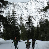
Enough about snow science. The next two pictures were the last of the day as I skied back.


Tuesday, I attempted to drive to Mores Creek Summit with my son Fritz. The road to the pass was closed for most of the day. Below a picture of the rotary plow as we patiently waited for it to clear the road.


But the plow kept having problems.


Finally the road supervisor caught with us at Twelve Mile creek, and politely requested us to drive back to Idaho City. After waiting from 8 AM to 1 PM, we gave up and drove home.

Cheers!

Chago

Sunday, April 4, 2010

Freeman Peak - Easter Weekend 2010

It has been some time since my last posting on this blog. March was a very busy month with several guiding trips at Wallowa Alpine Huts Norway camp, as well as teaching the last avalanche courses of the season (Avalanche Level 1 and Level III). Besides, my corporate job demanded a lot of me as well during this month.

For your enjoyment I embedded a slide show for one of the early March trips.


Below another photo album for my last guided trip of the season:
WAH 3202010
This weekend I visited Freeman Peak Saturday and Sunday. The skiing was exceptionally good both days of the weekend, but on Saturday "face shots" were a pleasant surprise for April Pow skiing!

Stability tests and snow observations during Saturday did not produce any evidence of instability with the exception of two small loose snow avalanches at steep areas (L-N-D1-R1-N). But the more than 40 cm layer of recent snow was non-cohesive. With careful observation it could be detected a storm interface below 20-25 cm. The top 20-25 cm of snow consisted of stellar crystals, fragmented particles, rimmed crystals, and graupel - what a cocktail!

The weather on Saturday was unsettled, with numerous snow showers and cold temps (-6 degrees C). Poor visibility negated us from taking any pictures or videos on Saturday. But the next picture taken Sunday morning shows the last run we skied Saturday:


Mores Creek area North and East aspects continue to have midwinter conditions, and the snowpack is very healthy. Judge by yourself after reviewing the next pictures snapped Sunday morning looking into Freeman lower E and NE aspects slopes close to I-21 road:


Saturday we were a crowd (Fritz, Joel, Dave, Brandon, Dave, Carlos, and Bill), but on Sunday, Pedro was my only companion. Next a picture of Pedro skinning up and skiing down.


Pedro on the first run of the day, skiing a shoulder run at 7400 feet on the Freeman east-to-west ridge that drops to the headwaters of Mores Creek at 6400 feet.


Sunday's milder temperatures (see next chart for temps above 0 degrees Celsius on April 4th)


and the sun warming effect densified the snowpack top layers, thus stability progressively deteriorated during the day. Soft slab conditions at E and NE aspects were confirmed with CTEQ2 with propagation potential (PST30/100) stability test results at the 25 cm and 50 cm layers on a 27 degrees slope. In addition, a slope cut at 6500 above a steep roll-over produced a small (15 meter) half a meter deep "soft slab" avalanche as well. Based on the stability results we did not exceeded slope angles above 35 degrees, and exercised caution on steep N and NE slopes between 7000 and 8000 feet.

It was sobering experiencing the vastly different stability due to temporal variability just within a weekend (Saturday & Sunday) in the same slopes! But, with good selection of slopes we found great powder and safe slopes, as shown in the next pictures from Pedro:


The next two pictures show Freeman Peak East Summit with open meadow skiing at the 8000 feet. Pedro and I left some tracks behind, more obvious with the second telephoto picture.


Pedro enjoying himself on the last run of the day:


It was a fantastic weekend of backcountry skiing, but hopefully not the last time we will ski POW this season, particularly when more snow is possible early this week.

Chago

Saturday, March 6, 2010

Bogus Sidecountry

Earlier today I had the opportunity to ski the Bogus Basin sidecountry with a friend and had lots of fun. The relaxed start was nice, and after losing each other and finding each other, we were off to the races. We ended up going to the same area that my dad went with my brother (check it out below).

The skiing was fun, because although there was a breakable crust, it had an interesting effect. Instead of catching your turn, it acted like a trampoline that let you bounce up and down.

While taking in the gorgeous views and eating lunch we also were able to collect same data. The primary concern was a surface hoar layer buried about 40 cm down. Although there was no propagation, the CTs were in the moderates and it definitely was energetic (Q1). The second thing we saw was that in the top 5-10 cm there was a layer failing in the easy CT range. Upon further looking the culprits of this potential future instability were near-surface facets. Also interesting to note, on the 40 down SH layer you could look with bare eyes (or magnifying glass) and see the surface hoar laying down.

Although we decided that jumping on the steep NW rockband coulours may not have been a good idea, we still had some great shots. It was definitely a little technical below the tree line, but that is part of the backcountry experience!

Pedro Rodriguez

Monday, February 15, 2010

Bogus Basin Sidecountry - 2/15/2010

Hello my friends!

It has been few weeks since the last posting. The last weekend of January I was teaching the final session of a NSP Avalanche Level 2 course at Soldier Mountain Resort. I was privileged to have some of the hardest working students any instructor can ever wish for. After a December weekend at Brundage and the Payette forest, another January weekend at Bogus Basin and Mores Creek Summit, and a final weekend at Soldier Mountain resort, with the last day touring around Peak 1, it was time to be done with this NSP course.

Once the NSP AVI L2 course was completed, I switched gears to ski guiding trips for Wallowa Alpine Huts (http://www.wallowahuts.com/). The last week trip was my second guided trip for the season, and it was a trip full of POW turns, and a MOST fantastic group of clients. Slopes below 8000 feet rewarded us with safe steep skiing (excess of 40 degrees!).


We were also blessed with some alpenglow views, check Norway Peak - Southern Wallowas, NE-Oregon:


Anyway, time to switch gears to the Idaho Mountains. Today I skied Bogus sidecountry with Fritz, my 16 year old son. We had a great time skiing the North bowl of Bob's Knob as well as its NW glades to the north-east of the Pine Creek Chairlift.

Please refer to posting from April 2008 with "beta" this general area:


The next short video was filmed today during our outing. Not bad skiing considering the the snow was Moist!


Some Pictures of the area we toured and skied:


Nice open slopes (above), and fabulous tree skiing (below).


But not everything was perfect - we had periods of DENSE fog.


Fritz playing with his split-board:


As my son had some lunch I quickly studied the snowpack on a 32 degree slope with a NNW aspect:
  • The snow depth ranged from 1.4 to 1.6 meter, and the hardness transitions gradually from Fist (top 20 cm), to 4F (next 40 cm), to 1F (60 to 1.2 m). The bottom 10 cm of the pack has DH but is showing signs of bonding with a hardness of 4F, not the typical cohesion-less crystals.
  • Compression column stability tests had Q3 quality shears at 30 and 40 cm, with Moderate and Hard compression scores respectively.
  • The most recent 10 cm layer of new snow above SH was reactive to "tilt test" in "easy range, but the "shallow" soft slab conditions make it hard to detect during compression tests (CTEQ2). This layer is of little concern to the terrain we skied today. It is likely that the VERY moist top snowpack and warm temperatures will provide the conditions to destroy the SH below the new snow. But as snow continues to accumulate it will be prudent to track this weak layer.
  • Deep tap tests (where the top 50 cm of the snowpack was removed) did NOT produce any fracture below the 50 cm from the surface to the bottom of the snowpack. This is the first time of this season (for me!) where the bottom layers of the snowpack did NOT react to CT tests.
The snowpack observations for the Bogus Basin sidecountry are encouraging, and I hope they reflect a trend for the region, where the early season deep instability starts to become a lesser concern.

As the we returned to the top of Pine Creek chairlift the mid-afternoon fog started to clear.


Mores Mountain, north of Shafer Butte - Bogus Basin (not Mores Creek Summit).


View from Shafer Butte to the West, into the fog covered Boise Valley.

 I will attempt to go an a "Dawn Patrol" later this week, if we get new snow (maybe Wednesday), and share more obs on ski conditions for our area.

 Chago