Sunday, March 30, 2008

Winter Corner and Mores Creek Summit Ski Conditions for the last weekend of March 2008

Hola!

It is hard to believe that this was the last weekend of March. The ski and snowpack conditions at Mores Creek Summit are characteristic of Winter conditions. The snow coverage is fantastic! - so many lines to ski that had been out of reach for several years. And soft powder conditions can still be found easily.

Sunday Morning I ran into two friends while getting ready at the parking area. Gary and George, and my son Pedro were quite enthusiastic about exploring and skiing a ridge SE of Winter Corner that does not get a lot of visits. I had been asking around for beta on that area without success. The topo below shows the lines usually skied at Winter Corner (red lines). The Green lines show the approximate up-hill track locations.

To the SE of Winter Corner also in red, are the lines for the runs we skied at Double G-string. We felt that was an appropriate name for this area considering the narrowness of the ridges on the runs. And the fact that George and Gary names started with G.


Below a picture at the top of Double G-String looking to the east. As usual - click on pictures to access the full picture file at a higher resolution.


The top 200-300 feet of the Double G-string runs are wide open as can be seen on the picture below, and the lower 500-600 are nicely spaced old growth forest.


The snow conditions were superb on these North exposures, also well protected from the effect of West and NW winds that had been prevalent this years. Check the video included below:


Skiers on video are in order of appearance: Gary, Pedro, and George.

Mores Creek Summit (6-7000 feet) received ~30 cm of new snow, and depending on exposure, quality varied from dry powder (North protected shots), to creamy denser snow at NE aspects, to breakable crust at Eastern aspects. But the Gestapo level of snow was located at West exposures with a combination of wind and melt crust. We follow ONE rule today - SKI NORTH aspects only!

Today, the temperatures varied from -6 Degrees-C in the morning to a maximum of - 2 Deg-C. The Wind was light from the SW. It started as a clear day, becoming cloudy by mid-day, and obscured by the afternoon. Thus wind, sun, and temps had a minimum effect on the snow today. If you search for powder at Northerly aspects - you WILL find good powder skiing early this week.

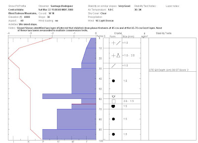
The snowpack remains unchanged from last week, with the exception of the new 30+ cm of low density snow. The snow has bonded nicely to the crust underneath, and clean shears were absent at NW, N, and NE aspects of Winter corner. It is reasonable to expect similar observations at Freeman and Pilot Peak area. Please refer to last weekend blog entry for the snowpit profile. You might have notice the lack of any significant temperature gradient in the snowpit data - and with the latest addition of snow with temps at -5 Deg C (top 10 cm), it can be said that the pack is in winter paralysis - changing very little - e.g. high strength, unresponsive weak layers to compression tests, and no energy for fracture initiation and propagation.

This can change later this week with the expected warmer temps. Please, keep that in mind! - snow stability can deteriorate with warming trends - particularly as deeply buried facets layer can become sensitive due to temperature induced differential strain rates (creep), and reduced snowpack strength during the heat of the day. We should continue to pay attention considering the latest Moderate and Considerable Avy forecast for North and Central Valley Sun Valley as well as the Payette Lick Creek summit areas, where they had been dealing with sensitive facet layers.

There are two other topics I would like to cover;

  1. We need to support Idaho City local economy, particularly when we enjoy so much the Mores Creek Summit area. Make a point of stopping at the local eaterys - even for something as simple a an ice cream or milk-shake.
  2. Not all backcountry skiers can arrive at Mores Creek Summit by 8-9 AM. Can we park in a manner that allows for additional parking? What about parking in a slight angle instead of parallel to the road? Twice in a week I received feedback from users to encourage backcountry skiers reading the blog to help with the parking situation.

Monday, March 24, 2008

Pilot Peak Conditions, Snotel Data, and Skiing at Bogus Side-Country

Hola Amigos!

We had today (Monday) another day of warm temperatures in the mountains. Temperatures at the Mores Creek summit located at 6100 feet reached 50 Deg-F. The good news is that even on cloudy nights, the temperatures had been dropping below the freezing level. That has contributed in maintaining a winter pack at most aspects and elevations (> 6000 feet) at Mores Creek Summit area. The warmer south aspects are also receiving a solid freeze.

A good friend provided the following summary for Monday skiing at Pilot Peak:

GD and I skied some of the northerly aspects off the east ridge of Pilot today. It was definitely true that if we wrapped around to a NE aspect, or got onto anything that receives sun, there was variable snow with a breakable crust. There was still powder in the protected north faces, though, pretty nice. It snowed steadily for a couple hours, but with little accumulation.

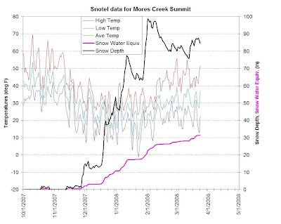
A cursory inspection of the latest Snotel data included below shows a temperature average trending above 32 Deg-F. Such temperatures allow the snowpack to settle, thus promote sintering. That snowpack stabilization was validated this weekend by the lack of active layers during compression stability tests.


As the average temperature continues its upward trend, it is a good idea to keep in mind that there is a period when a winter to spring transitional snowpack might become unstable as it looses strength due to radiation and/or convective heating. And this last weekend (check previous blog posting) some layers of concern were identified.

Sunday I was lucky to ski the Bogus Basin side-country. I skied at two locations outside the resort boundaries; NE of Shaffer Butte and SE of Deer Point. Included below the topo maps for these two areas:


In red the runs I skied Sunday. The green trace on the second topo map was already tracked, so I did not skied it, but use it for the uphill track. The ski line on the first topo map was named by my "Backcountry Boarder" son as Nirvana earlier this winter. Below I include a short video clip from that early January day with my two sons, Pedro and Fritz.


The name reflects the snow quality of this line when we have winters with abundant snow due to its wind sheltered North aspect. This area is accessed via the backcountry gate between the Resort Triangle and Stump Patch areas.

Last Sunday it was fun skiing Nirvana with 20-25 com at the top 400 feet, but the lower 200 feet had a "dust on crust feel" with barely 10 cm of new snow in top of a bullet proof rain crust. Once I got to the very steep creek bottom, right next to a bloody mountain lion den, with bloody leftover bones lying around ... I realized that it was smart to skin-up FAST .. but skinning was not an option ... as hard as I tried I could not punch through the crust, and I could not get the edges/skin to bite on the steep creek bottom. With my heart racing, I had to boot-up 200 feet to be able to finally put in a track on the deeper new snow.

After skiing Nirvana, I assumed (due to overcast nature of the day) that there was no chance of skiing "corn" at Boise Front below Deer Point, but I wanted to check it out - and scout it - it has been 2 years since the last time I skied them. This ski terrain has elegant steep lines, with drops in excess of 1200 feet, and some of the best corn anywhere!

To my DELIGHT and SURPRISE the slopes to the SE of Deer Point had perfect corn. And I mean 2 cm of perfect corn - not slush! I have no idea how it happened, since it was a cloudy day. I guess the combination of temperatures, low wind, high density isothermal pack, and cloud cover produced the corn snow. Too bad I had to get home to manage the BBQ - or I would had skied a third line!

Check the blog later in the week, since I will be visiting the backcountry, and I will be posting updated ski and snow conditions.

Saturday, March 22, 2008

Snow Conditions for Late March 2008

Hello!

It has been several weeks since the last posting with information about Mores Creek Summit area snow conditions. I had been guiding a lot this year in the backcountry, and between my REAL job and family responsibilities - there have been no time to visit Mores Creek Summit.

Today Pedro (my oldest son) and I finally skied Freeman this month. It was a bluebird SUNNY day ... the snow was nice ... well check a video taken today - and you can judge by yourself the snow quality. The skier is Pedro.


The snow was really fun at NW/N/NE protected aspects. But as you move around into NEE aspects - there was a zipper crust. Easterly aspects had a good array of instructional snow, but below 7000 feet the crust softened later in the day into some creamy snow -not bad skiing. There should be in sun protected areas additional nice snow waiting to be skied, but Sunday predicted higher temperatures might start affecting these last pockets of good skiing.

A study snow pit profile at 6800 feet - NEE aspect - 30 degrees steep at Freeman looked like this (click on the image to get it magnified - I do not want you to blame me for loosing your eyesight):


As documented in the pit above, compression tests were unremarkable. The new snow was the only layer that reacted to the compression test and it showed a very sluggish Q3 shear quality. It is prudent to keep an eye at the facets buried at 65 cm - they might get revitalized during the spring as the pack becomes isothermal. Shovel shears at this layer showed a very distinctive and clean planar surface - suggesting that up to this point these layer is NOT bonding well.

In another location (7000 feet, NE aspect, 35 degrees steep) stability tests again were unremarkable; CTEQ3 - at the top 25 cm layer (new snow). The test results were consistent for the 3 compression columns tested. The test pit at this more protected location lacked the crust layer (55-60 cm) observed at the other NEE pit. But the rest of the snowpack structure was pretty much the same.

In summary, the Mores Creek Summit snowpack at NW/NE/N aspects at elevations above 6500 feet have all the attributes of a winter snowpack.

It is worthwhile noting that temperatures at shady protected areas were in the range of -5 to -3 degrees C, and in the lower end at mid elevations (6800-7200 feet). For less protected areas and at higher elevation (+7800 feet) the temperatures at shady spots hovered around 1 degree C. These temperatures correlated well with the quality of the POW - the best skiing was at mid elevations in shady sheltered aspects.

Next week storm is expected to be relatively cold for late March - and if we get more than 15 cm of snow - it will be really good skiing. Get out an enjoy!

Chago